When we were in the North Island of New Zealand, we didn’t do as much hiking as in the South. But one thing we knew for sure was that we had to do the Tongariro Alpine Crossing, one of the greatest day walks in New Zealand.
The total distance of the walk is 19.4 km, making it the longest walk that we did in New Zealand.
It features a distinctive combination of volcanoes, craters, and lakes, so we were definitely looking forward to completing the walk.
Beginning the Climb of the Tongariro Alpine Crossing
The campground where we stayed is called Discovery Lodge.
They provide a shuttle bus to the starting point of the Tongariro Alpine Crossing and pick us up afterward.
Keep in mind that the crossing is not a loop, meaning it starts and ends at different points.
Unless you want to walk another 19 km back to the starting point, or perhaps only do a half circuit, taking the shuttle bus is a practical choice.
Check out this Guided Group Walk!
It takes us to the Mangatepopo Carpark and picks us up at the Ketetahi Carpark once we’re done.
We booked the first shuttle bus, leaving at 5:30 a.m.
The driver checked all our equipment; it is essential to bring a raincoat or waterproof jacket for safety reasons, as the weather can change unpredictably.
It didn’t take too long to reach the Mangatepopo Shelter.
We fueled up before starting the walk by having a simple breakfast while watching the sunrise.
At the beginning, the walk is relatively easy. The main track climbs alongside a stream and around the edges of old lava flows.
The land is so barren that no plants can grow. There’s a side track to the Soda Springs, but we skipped that and continued to the South Crater.
Up to the Red Crater and Down to the Emerald Lake
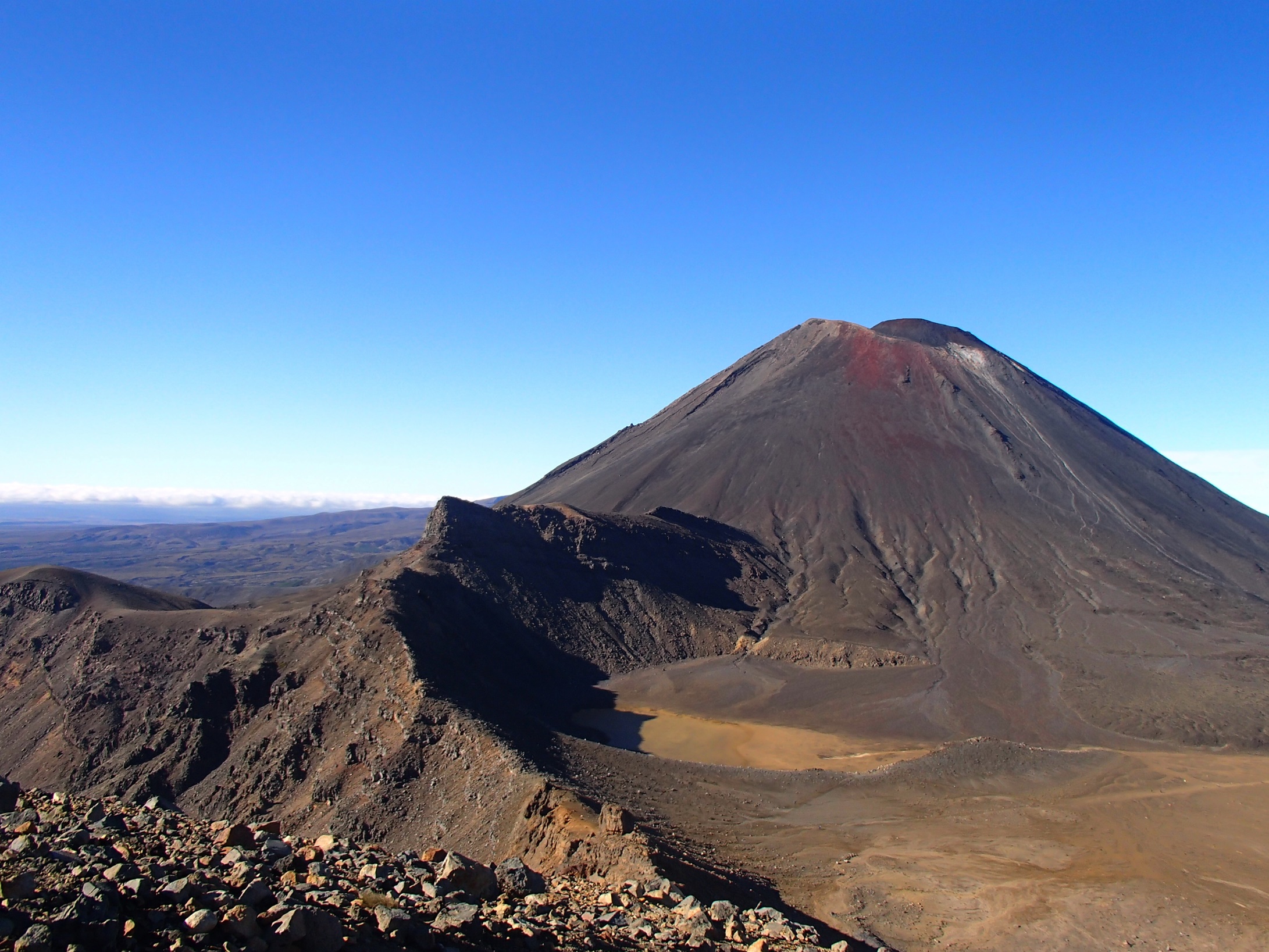
Climbing steadily at a normal pace, we reached a turn-off with a sign pointing to another side track, to the top of Mt. Ngauruhoe.
We discussed whether we wanted to add an extra three hours to complete the summit track.
It looked challenging, very steep with all these loose volcanic rocks.
But no, we decided against it. Just staring up at the summit sent chills down my spine
 The view of Mt. Ngauruhoe from the ridge
 Climbing up the loose rocks
We followed the poles to the ridge leading up to the Red Crater. I started to breathe heavily as the track got steeper.
However, I felt excited; it reminded me of Mount Rinjani in Indonesia.
Red Crater, at 1886 meters, is the highest point of the Tongariro Alpine Crossing.
There’s another path leading to the Mt. Tongariro Summit, which is an additional two-hour detour from the Red Crater.
Here comes the most difficult part for me.
I don’t mean to say I have a phobia of heights, but I’m genuinely scared of steep descents, especially on loose, rocky terrain like this.
But believe me, the view from up here was absolutely marvelous.
I could see the Emerald Lake below, sparkling like a jewel as it reflected the sun’s rays.
We were so lucky to have such nice weather. Carefully, I slid down to the lake—it was time to capture some pictures!
 Steep climb to the Red Crater
 The Emerald Lake
 Closer look to one of the lake
You can see thermal steam around this area and smell the sulfur.
The color of the lake is caused by minerals leaching from the adjoining thermal area.
After finishing our photo session, we continued ascending to the Blue Lake.
This is actually my favorite part of the Tongariro Alpine Crossing.
Standing there, looking at the lake, I felt as if I were transported to a different dimension.
But it doesn’t stop here. The picture-perfect landscape of the mountains struck me profoundly.
The mountains seem to stand next to each other, presenting a breathtaking view.
There’s Mt. Ruapehu, with its glacier on top, and next to it, Mt. Ngauruhoe, the ideal look of a volcano, followed by the Red Crater.
Don’t you think it’s unique for a snowy mountain and a volcano to stand side by side? You know what I mean?
 The Blue Lake
 View of Mt. Ruapehu, Mt. Ngauruhoe, and the Red Crater
 Closer look
Heading Back Down to Ketetahi Car Park
That day was extremely hot, and we were walking without any shade.
From the Blue Lake, the track easily spirals down to the Ketetahi Carpark.
There wasn’t much else to see except tussocks, a few streams, and oh, the view of Lake Taupo can be seen from up here.
It wasn’t until the last part, which was a bit forested, that we finally found some shade.
Upon reaching the carpark, we waited for the shuttle to pick us up, and that was it—the journey ended.
In total, it took us 7 hours to finish the crossing.

Read also:
- New Zealand Road Trip Itinerary 4 Weeks (South + North)
- Uluru Travel Guide: Discovering The Aboriginal Culture
- Hiking Jade Mountain or Yushan National Park, Taiwan
We try to provide the most accurate information; however, conditions and prices may have changed. Please let us know if you notice any discrepancies so we can update this article. Thank you for contributing and helping other travelers!
Liking the content so far? If so, I would greatly appreciate your support. You can help by making a purchase through my affiliate link, which allows me to earn a commission at no extra cost to you. This support enables me to continue creating free resources like this!
Leave a Reply