How is it like to hike the longest mountain track in Java – Mount Argopuro? Check out my experience here!
Mount Argapura often called as Argopuro is a no longer active volcano in East Java, precisely administrated in Probolinggo Regency.
This volcano is less popular compared to its neighborhood volcanoes, Mount Semeru and Raung, but it can’t be underestimated.
Besides, Mount Argopuro holds the predicate as the mountain with longest track in Java, almost 40kms in total. The profound beauty lies within the enticing view of the landlocked savannas, tucked away in the valley of Mount Argopuro.
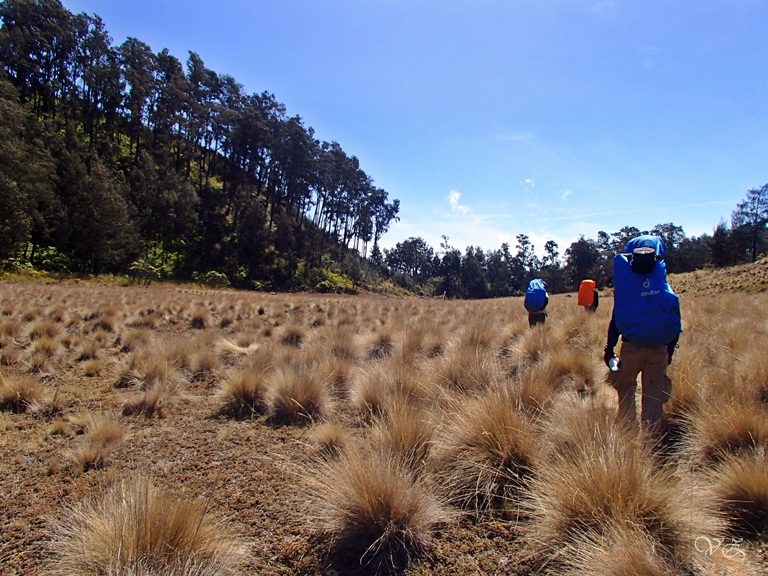
Yellowish color of tall blady grass, then switch to the dense flowery bushes, that’s the typical track that hikers will find. There are three eulogised peaks with the highest one vaults 3,088 meters above sea level.
A group of mine, encompassing of five people in total did 4 days hike in total. We started via Bremi and ended up in Baderan.
How to get to Mount Argopuro
The closest big city from Mt. Argopuro is Probolinggo. It is accessible 24 hours by bus from Surabaya. From Probolinggo, you can choose whether you want to start from Bremi or Baderan.
Easiest way, you can rent private car/van from Surabaya but if you wish to do it with public transportation:
- Probolinggo-Bremi (Terminal AKAS Lama): From 6 a.m.- 5.30 p.m., (2 hours, Rp 17.000)
- Probolinggo-Besuki (by bus to Situbondo, 1 hour)-Baderan (angkot, 45 minutes): From 6 a.m. till late. It won’t cost you more than Rp 50.000
Entrance Fee to Mount Argopuro: Rp 20,000/day in weekdays, Rp 30,000/day in weekends (Indonesian), Rp 250,000/day in weekdays, Rp 375,000/day in weekends (Foreigners)
Read Also: Hiking in North Sumatera, Mount Sibayak and Sinabung
Via Bremi or Baderan?
Based from my past experience, I would definitely stick to Bremi, and finish it in Baderan.
Even though it’s steeper, but the ascending takes you only in the first day.
Rest of the days, it’s just downhill, even though the last part, which is the beginning of Baderan was crazy like hell.
However if I’m reversing the condition, ascending from Baderan will be more racking cause it is a super long way, like it’s never going to end.
Itinerary Hiking Mount Argopuro
Overall we spent 4 days for the hike. Here’s our itinerary hiking Mount Argouporo starting from Bremi and finishing in Baderan:
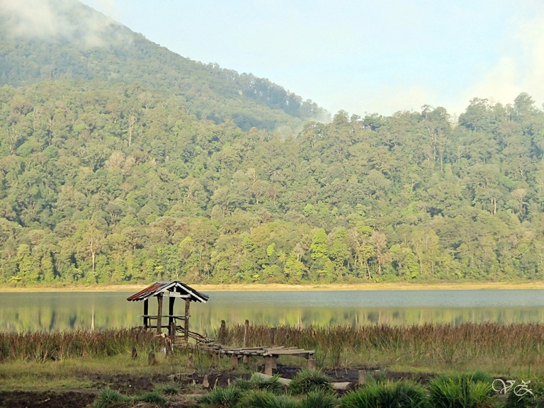
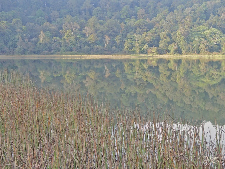
Day 1 (12 p.m. – 3.30 p.m. / 3.5 hours) : Bremi – Taman Hidup Lake
After passing through the villagers’ farms, we broke into the rain forest, with a not so steep ascending track.
There were two track options, a faster cutting path but steep, or an endless boring not so steep turning path like a snake movement until Taman Hidup.
Gladly, we arrived in the lake just before the sun came down, so we could still capture an intriguing reflection of the lake.
Day 2 (9.30 a.m. – 5.30 p.m. / 8 hours) : Taman Hidup Lake – Junction
There’s no water source ahead until the next day, so we loaded up water from the lake, and continued our journey to the junction.
The track turns fiendishly at the last 3 hours before the junction. Steep ascending with heavy bags on the back, that’s a hard work.

Day 3 (6.40 a.m. – 5.15 p.m. / 10 hours) : Summit attack – Cikasur
We spent almost three hours for taking pictures in three peaks, close to each other.
First was Arca/Hyang Peak, only 15 minutes from the junction. Next Argopuro peak, and last Rengganis Peak.
To be honest the peaks here were not as outstanding as the peaks from other mountains, but I would highlight Rengganis Peak, not actually the peak but the track before the peak was a vestige land of sulfur, full of white rocks.
From the junction it takes around 1 hour to the next water source, Rawa Embik. We rushed to our next camp ground Cikasur. Along the way, the blady grasses were everywhere!
Read Also: Mount Rinjani Hike in Lombok, Indonesia
Day 4 (9 a.m. – 7 p.m. / 10 hours) : Cikasur – Baderan
Initially our plan was camped at Pos Mata Air I then continued the rest 4 hours to Baderan on the next day, but we decided to pull it off until the last.
The track was fine, straight and slope through uncountable savannas.
It was just fine until Pos Mata Air 2, where next torturing part happened, a small path with a size of one foot concave in between, worsen by the dust from the soil.
My feet sore really bad from the last 2.5 hours pebbled path, finally we made it to the end, safely.
That was our short rough experience of our journey.
There are plenty water sources in Mt. Argopuro, However, prepare more water between Rawa Embik-Taman Hidup because no water in between and it can take another one night to stay.

To sum it up, this journey was different from my usual hike, and this mountain for sure has a very special landscape, the savannas.
I felt completely tiny, in the middle of such a huge savannas.
Probably they were about seven savannas that we met, along the way.
Cikasur was one of the best camp ground that I’ve been to, I won’t forget, the moment I woke up and the sun was just about to rise up, and the light just created a magic golden color in the savanna.
Thanks as well to Vivi, Anton, Irvan, and Andreas, you guys made this trip fantastic!


If you think the post is useful, kindly share this information by clicking the logo below. You’ll be directed to your facebook or twitter.
Liking the content so far? If so, I would greatly appreciate your support. You can help by making a purchase through my affiliate link, which allows me to earn a commission at no extra cost to you. This support enables me to continue creating free resources like this!
Leave a Reply